Wool houses [6]
Introduction
The photograph on this page of Wool houses [6] by Michael Dibb as part of the Geograph project.
The Geograph project started in 2005 with the aim of publishing, organising and preserving representative images for every square kilometre of Great Britain, Ireland and the Isle of Man.

There are currently over 7.5m images from over 14,400 individuals and you can help contribute to the project by visiting https://www.geograph.org.uk
Wool houses [6]
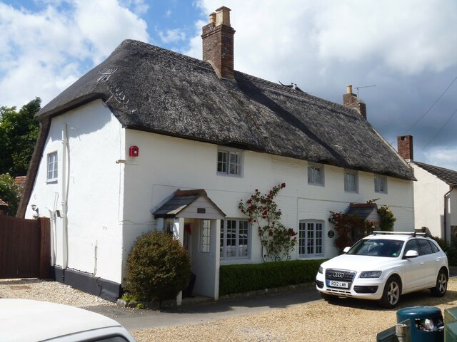
Image: © Michael Dibb Taken: 31 May 2022
Burvan House, number 24 High Street (nearer the camera) and April Cottage, number 23 High Street were originally one house and later a house and shop. Number 23 was built in the 18th century, number 24 was built, probably, in the early 19th century. Number 23 is constructed of painted brick, Number 24 of plastered rubble stone, both under a thatch roof. Listed, grade II, with details at: https://historicengland.org.uk/listing/the-list/list-entry/1120372 Wool is a large village in Dorset, midway between Dorchester and Poole, both about 10 miles distant. Set on the south bank of the River Frome, the village includes Bovington Camp army base to the north. The place-name 'Wool' is first recorded in Anglo-Saxon Writs in the first years of the 11th century. The ruins of Bindon Abbey are nearby, demolished in 1539, the stone was used to build castles in Portland, Lulworth and Sandsfoot.
Images are licensed for reuse under creativecommons.org/licenses/by-sa/2.0
Image Location


Leaflet Map data © OpenStreetMap
Latitude
50.678448
Longitude
-2.219279