
Murals in the pedestrian underpass on Foxcovert Walk, Werrington
Introduction
The photograph on this page of Murals in the pedestrian underpass on Foxcovert Walk, Werrington by Paul Bryan as part of the Geograph project.
The Geograph project started in 2005 with the aim of publishing, organising and preserving representative images for every square kilometre of Great Britain, Ireland and the Isle of Man.

There are currently over 7.5m images from over 14,400 individuals and you can help contribute to the project by visiting https://www.geograph.org.uk
Murals in the pedestrian underpass on Foxcovert Walk, Werrington
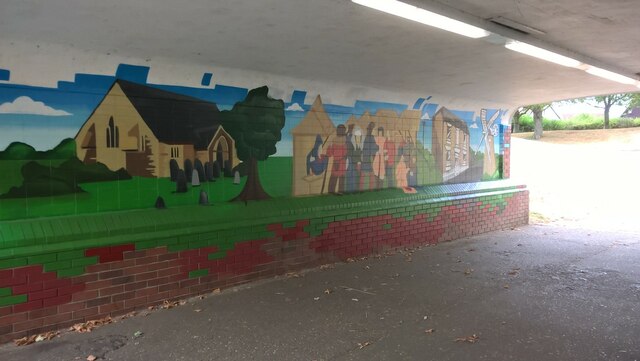
Image: © Paul Bryan Taken: 27 Jul 2022
The murals in the pedestrian underpass on Foxcovert Walk were repainted in June 2022. They depict local scenes including the Church of St. John The Baptist and the former windmill on Lincoln Road. The underpass passes underneath David's Lane. The pathway follows the route of Foxcovert Road (also spelled as Fox Covert Road), which previously connected Werrington on the northern periphery of Peterborough with the villages of Glinton and Peakirk. It was created in the 1980s when the area was extensively developed with the construction of houses, schools and retail and leisure facilities. Foxcovert Road was split into two when the level crossing on the Peterborough to Lincoln railway line near Glinton was closed to motor traffic during the 1980s. The two sections are no longer linked for motor traffic although the route remains accessible to pedestrians and cyclists. For an image of the actual Church of St. John The Baptist (as portrayed in this mural), please see: Image
Images are licensed for reuse under creativecommons.org/licenses/by-sa/2.0
Image Location

Latitude
52.62529
Longitude
-0.278266