Information board, Portstewart
Introduction
The photograph on this page of Information board, Portstewart by Kenneth Allen as part of the Geograph project.
The Geograph project started in 2005 with the aim of publishing, organising and preserving representative images for every square kilometre of Great Britain, Ireland and the Isle of Man.

There are currently over 7.5m images from over 14,400 individuals and you can help contribute to the project by visiting https://www.geograph.org.uk
Information board, Portstewart
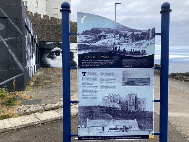
Image: © Kenneth Allen Taken: 22 Jul 2022
Located at the start of the cliff walk - it includes the following text: This end of the Crescent is dominated by the view of the Promenade opposite 3nd the 'Castle' above. This view of Portstewart has sight of the four main churches in the town, which are. Portstewart Presbyterian Church, Portstewart Methodist Church, Star of the Sea Roman Catholic Chapel and Agherton Parish Church, Above ts "Rock Castle" which was built by landlord Henry O'Hara in 7834, This was home to the O'Hara and Montagu families and others before being sold to the Dominican Order in 1917. becoming firstly a Convent School and later the co-educational Dominican College, At the bottom of the rock face here, on a site once occupied by a row of thatched fishermen's cottages known as "Bone Row", stands a sports hall belonging to the College, Formerly the "Top Hat" and "Strand" ballroom, the building holds many musical memories from the 1950s and 1960s for the young people of those times. The steps lead to a well-trodden path known as the "Cliff Walk", which leads to Portstewart Strand. The basalt wall adjoining the route was constructed during the mid 1800s as a famine relief project to provide work for the needy.
Images are licensed for reuse under creativecommons.org/licenses/by-sa/2.0
Image Location
Latitude
55.182411
Longitude
-6.722339