Great Wishford features [2]
Introduction
The photograph on this page of Great Wishford features [2] by Michael Dibb as part of the Geograph project.
The Geograph project started in 2005 with the aim of publishing, organising and preserving representative images for every square kilometre of Great Britain, Ireland and the Isle of Man.

There are currently over 7.5m images from over 14,400 individuals and you can help contribute to the project by visiting https://www.geograph.org.uk
Great Wishford features [2]
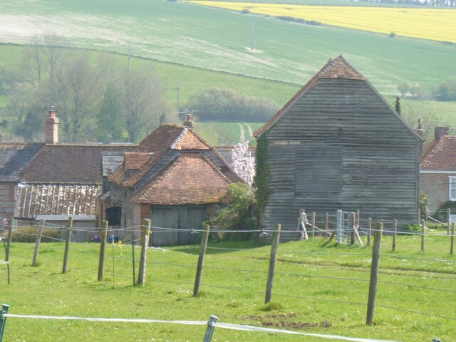
Image: © Michael Dibb Taken: 20 Apr 2022
Seen from near Station Road are this stable building (on the left) and granary (on the right). These two buildings belong to Wishford Farm and are located at the rear of Beehive House in South Street. The stable is 18th century with early 19th century extensions. Timber framed and weatherboarded over a flint and limestone plinth under a half-hipped tile roof. Listed, grade II, with details at: https://historicengland.org.uk/listing/the-list/list-entry/1318712 The granary is late 18th century. Timber framed and weatherboarded on staddlestones under a half-hipped tile roof. Listed, grade II, with details at: https://historicengland.org.uk/listing/the-list/list-entry/1284424 Great Wishford is a village in the valley of the River Wylye in Wiltshire, some 6 miles northwest of Salisbury. The village was settled in the Saxon period and was known as Wicheford (meaning a ford where wych-elms grow). Great Wishford celebrates Oak Apple Day on the 29th of May each year, when villagers claim their ancient rights to collect wood from Grovely Wood. The tradition is said to date back to 1603.
Images are licensed for reuse under creativecommons.org/licenses/by-sa/2.0
Image Location


Leaflet Map data © OpenStreetMap
Latitude
51.117762
Longitude
-1.887268