Canterbury buildings [247]
Introduction
The photograph on this page of Canterbury buildings [247] by Michael Dibb as part of the Geograph project.
The Geograph project started in 2005 with the aim of publishing, organising and preserving representative images for every square kilometre of Great Britain, Ireland and the Isle of Man.

There are currently over 7.5m images from over 14,400 individuals and you can help contribute to the project by visiting https://www.geograph.org.uk
Canterbury buildings [247]
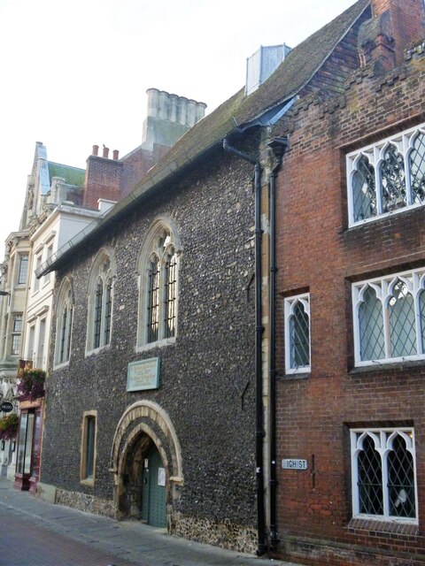
Image: © Michael Dibb Taken: 13 Sep 2021
Number 26 High Street, seen here, and number 25 High Street Image form the Eastbridge Hospital. The right side, number 25, has a 12th century hall and undercroft with 17th century work above, refronted in the early 19th century. Timber framed, the front in red brick with crenellated parapet, all under a slate roof. The left side, number 26, is faced with knapped flint and has stone dressings and quoins, all under a tiled roof. The hospital was established for the poor pilgrims visiting the shrine of St Thomas Becket. After the Dissolution the building was turned into almshouses. Listed, grade I, with details at: https://historicengland.org.uk/listing/the-list/list-entry/1085030 Canterbury is a small historic city on the River Stour in Kent, some 54 miles southeast of London. Occupied since prehistoric times, it became an important Roman city. In 672, the see of Canterbury gained authority over the entire English Church. After the murder of Archbishop Thomas Becket at the cathedral in 1170, pilgrims from all parts of Christendom came to visit his shrine until the Dissolution. Today, Canterbury is a popular tourist destination and one of the most-visited cities in the United Kingdom. The city has a substantial student population, with four university campuses.
Images are licensed for reuse under creativecommons.org/licenses/by-sa/2.0
Image Location
Latitude
51.279823
Longitude
1.078419