Ospringe houses [11]
Introduction
The photograph on this page of Ospringe houses [11] by Michael Dibb as part of the Geograph project.
The Geograph project started in 2005 with the aim of publishing, organising and preserving representative images for every square kilometre of Great Britain, Ireland and the Isle of Man.

There are currently over 7.5m images from over 14,400 individuals and you can help contribute to the project by visiting https://www.geograph.org.uk
Ospringe houses [11]
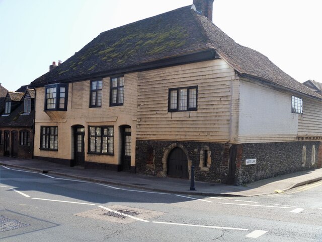
Image: © Michael Dibb Taken: 5 Sep 2021
Number 15 Ospringe Street is sited on the corner with Water Lane. The right part of the building was part of the medieval hospital of Maison Dieu. There is a 13th century undercroft in flint below a timber framed first floor, jettied to Water Lane, partly rebuilt in red brick and partly tile hung. The left part is 17th century in painted brick, the whole under a tile roof. Listed, grade II*, with details at: https://historicengland.org.uk/listing/the-list/list-entry/1069430 Maison Dieu, the Hospital of Blessed Mary of Ospringe was a hospital, monastery, hostel, retirement home and royal lodge commissioned by Henry III in 1234. Its purpose was to care for the sick and aged. Pilgrimage was the legitimate reason for the poor to travel and the Maison Dieu was the last stop on the journey to Canterbury. Henry III added a Camera Regis or “King’s chamber” to enable royalty to stay at the Maison Dieu and many Kings and Queens stayed here. There is more detail at https://maisondieu.org.uk and at: https://en.wikipedia.org/wiki/Maison_Dieu,_Faversham Ospringe is a village and area of Faversham, Kent. The village lies on the Roman road Watling Street (now the A2). The historic Maison Dieu fronts onto Watling Street and the remains of substantial Roman buildings, thought to be the site of the Durolevum mentioned in the Antonine Itinerary, have been found nearby.
Images are licensed for reuse under creativecommons.org/licenses/by-sa/2.0
Image Location
Latitude
51.311473
Longitude
0.873737