Historic road junction at Cold Harbour
Introduction
The photograph on this page of Historic road junction at Cold Harbour by Tim Heaton as part of the Geograph project.
The Geograph project started in 2005 with the aim of publishing, organising and preserving representative images for every square kilometre of Great Britain, Ireland and the Isle of Man.

There are currently over 7.5m images from over 14,400 individuals and you can help contribute to the project by visiting https://www.geograph.org.uk
Historic road junction at Cold Harbour
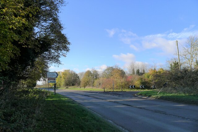
Image: © Tim Heaton Taken: 19 Nov 2021
The minor road coming in on the right is the B6403, which follows the line of the Roman road, Ermine Street, running from Lincoln (north, right) towards Peterborough (south, left). The main road is the A52, which from Donington (east, behind) to this point follows the route of the Salt Way. From this point the Salt Way crossed over Ermine Street and continued west to cross the River Witham at Saltersford. Much has been written on the origins of places called 'Cold Harbour'. The name is presumed to refer to a cold (exposed, bleak) place of refuge https://www.cantab.net/users/michael.behrend/repubs/karslake/pages/hahn.html , and it has been suggested that "Cold Harbours are all in the vicinity of one or other of the great Neolithic or Roman roads, and were originally the remains of partially destroyed Roman or Romano-British dwellings, or settlements" https://www.cantab.net/users/michael.behrend/aw_cuttings/ocr/p_117a.html , which could apply here. Other articles may disagree (Richard Coates, Coldharbour - for the last time?, Nomina 8, 73-78 (1984). http://www.snsbi.org.uk/Nomina_articles/Nomina_08_Coates.pdf
Images are licensed for reuse under creativecommons.org/licenses/by-sa/2.0
Image Location
Latitude
52.902415
Longitude
-0.587565