The Foundry, High Street Fordington, Dorchester
Introduction
The photograph on this page of The Foundry, High Street Fordington, Dorchester by Jo and Steve Turner as part of the Geograph project.
The Geograph project started in 2005 with the aim of publishing, organising and preserving representative images for every square kilometre of Great Britain, Ireland and the Isle of Man.

There are currently over 7.5m images from over 14,400 individuals and you can help contribute to the project by visiting https://www.geograph.org.uk
The Foundry, High Street Fordington, Dorchester
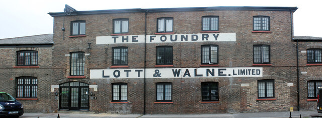
Image: © Jo and Steve Turner Taken: 23 Aug 2021
Grade II Listed early 19th century former foundry. Possibly established in 1830 it is not in Pigot's directory that year but in 1941 edition John Galpin is listed as iron founder High West Street having first appeared in 1839 edition of Robert's Directory as Ironmonger and Ironfounder. In 1851 he is employing 28 men and 4 boys suggesting he may have the foundry here but continued to live in High West Street. John went on to become Mayor of Dorchester 1861-2 and become its JP and an Alderman of the town. In 1865 he is listed as owner of the foundry at Fordington but by 1871 had sold his interest in the business. In 1875 Crocker, Fenner & Co. are 'Ironfounders & ironmongers of High East street & The Foundry'. By 1891 the foundry had been taken over by Foster Lott & Company and in 1901 it was Lott & Walne Ltd. The foundry closed in the 1980s. In 2001 a developers scheme for five houses here was rejected by the council but the foundry building went on to be converted into flats.
Images are licensed for reuse under creativecommons.org/licenses/by-sa/2.0
Image Location


Leaflet Map data © OpenStreetMap
Latitude
50.715487
Longitude
-2.432102