The Old Malthouse, High Street Fordington, Dorchester
Introduction
The photograph on this page of The Old Malthouse, High Street Fordington, Dorchester by Jo and Steve Turner as part of the Geograph project.
The Geograph project started in 2005 with the aim of publishing, organising and preserving representative images for every square kilometre of Great Britain, Ireland and the Isle of Man.

There are currently over 7.5m images from over 14,400 individuals and you can help contribute to the project by visiting https://www.geograph.org.uk
The Old Malthouse, High Street Fordington, Dorchester
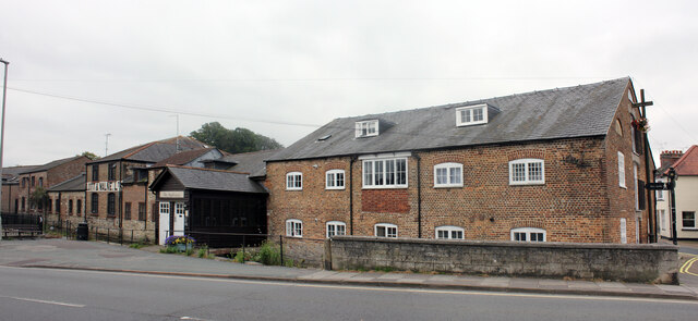
Image: © Jo and Steve Turner Taken: 23 Aug 2021
Grade II Listed late 18th or early 19th century malthouse. Now split into apparently two homes numbered 2A & 2B. The first owner was Elias Galpin (1756-1846) who lived here until his death so it seems safe to assume the building is late 18th century. A part of the Malthouse was known locally as the 'Noah's Ark Inn' a name in use at least from 1860 to 1940 although beer had been retailed here from 1830 or before. Elias' son Robert ran the business until his death in 1859. John & William Blandamer purchased the business from Robert's beneficiary in 1860. William's wife Amelia continued to run Noah's Ark until 1882. George Trevett was the next occupant until 1890 but is recorded only as publican/Innkeeper of the Noah's Ark Inn, not maltster a trade that possibly ended with Robert Galpin. In mid 1891 John Legg moved in and is recorded as Railway Carman and Publican. George Legg took over from his father on John's death in 1901. George continued at Noah's Ark until 1940 but records indicate other activities here by Horace Wrighton as 'fish hawker, greengrocer and cycle depot manager'.
Images are licensed for reuse under creativecommons.org/licenses/by-sa/2.0
Image Location


Leaflet Map data © OpenStreetMap
Latitude
50.715666
Longitude
-2.432529