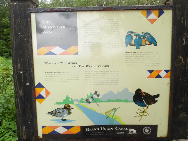
Information Board re Wildlife, The Wides and The Wendover Arm
Introduction
The photograph on this page of Information Board re Wildlife, The Wides and The Wendover Arm by David Hillas as part of the Geograph project.
The Geograph project started in 2005 with the aim of publishing, organising and preserving representative images for every square kilometre of Great Britain, Ireland and the Isle of Man.
There are currently over 7.5m images from over 14,400 individuals and you can help contribute to the project by visiting https://www.geograph.org.uk

Image: © David Hillas Taken: 19 Jun 2021
This information board is located by the Wendover Arm canal between Halton Lane and Wharf Road. It has the following wording: Top middle Built at the base of the dry Chiltern slopes, the Wendover Arm has enabled species such as the dragonflies and damselflies to hunt over large areas previously too far from water. Likewise species dependent upon aquatic plants, such as the moor hen, have been able to find homes where none would have been previously available. Perhaps the most spectacular of the Arm's commuters is the kingfisher. Although it is a shy bird, the quiet walker can often be rewarded by a brief glimpse of electric blue darting ahead a few feet above the water. The Wides.... Below the canal was cut across its path, one of the many springs arising at the base of the hills flowed through marshy grassland before forming a stream draining to the River Thame. One of the few naturally wet areas crossed by the Arm, this land now forms The Wides. Right Beyond The Arm...The opportunities for wildlife created by the building of the Wendover Arm go far beyond the waterway and its fringing vegetation. Weston Turville reservoir completed in 1799, was built to store excess water to compensate mill owners for the loss of the water flow from the Wendover Stream. With its extensive reedbeds and a marshy fen, the reservoir is now listed as a Site of Special Scientific Interest and is managed for wildlife by British Waterways and the Berks, Bucks and Oxon Naturalists' Trust. Middle left A Wildlife Corridor... Boats may not have used the canal since 1904 but the Wendover Arm is still a bustling transport route teeming with daily commuters and residents alike. Ever since it was first watered in the winter of 1796, the canal has acted as highway and haven for the many plants and animals that depend upon the water or its wet margins for part or all of their lives. Middle centre When the canal was first flooded, The Wides were open water and natural turning points or winding holes ("winding" because boaters used favourable wind to help turn the boat). Over time reeds have crept in from the banks, trapping silt as they do so. As they move further forward, the land behind becomes drier. Willow herb and reedmace grow into the drying reed beds, raising and drying the soil still further. Willow carr and damp woodland complete the slow succession from open water to dry land. Images of the canal together with kingfishers, damselfly, dragonfly, duck and moorhen can also be seen in this photo.
Image Location


