Milton Abbas buildings [1]
Introduction
The photograph on this page of Milton Abbas buildings [1] by Michael Dibb as part of the Geograph project.
The Geograph project started in 2005 with the aim of publishing, organising and preserving representative images for every square kilometre of Great Britain, Ireland and the Isle of Man.

There are currently over 7.5m images from over 14,400 individuals and you can help contribute to the project by visiting https://www.geograph.org.uk
Milton Abbas buildings [1]
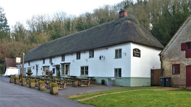
Image: © Michael Dibb Taken: 11 Dec 2020
The Hambro Arms Inn, The Street, was built circa 1780 with plastered cob walls and a hipped thatched roof. The inn was extended at the rear in the 19th century. Two canted bay windows flank the entrance. The former stable range is on the left. Listed, grade II, with details at: https://historicengland.org.uk/listing/the-list/list-entry/1118556 Milton Abbas is a small village in a wooded valley some 5 miles south west of Blandford Forum. This planned community was constructed circa 1780 when the inhabitants of the market town of Middleton were relocated here by the landowner, the Earl of Dorchester. Middleton was then demolished and the site landscaped. Recently the village has been extended above the eastern end of the valley. Every two years a historic country fair takes place here when the locals celebrate the rebuilding of their village.
Images are licensed for reuse under creativecommons.org/licenses/by-sa/2.0
Image Location


Leaflet Map data © OpenStreetMap
Latitude
50.816415
Longitude
-2.273767