Iwerne Minster features [2]
Introduction
The photograph on this page of Iwerne Minster features [2] by Michael Dibb as part of the Geograph project.
The Geograph project started in 2005 with the aim of publishing, organising and preserving representative images for every square kilometre of Great Britain, Ireland and the Isle of Man.

There are currently over 7.5m images from over 14,400 individuals and you can help contribute to the project by visiting https://www.geograph.org.uk
Iwerne Minster features [2]
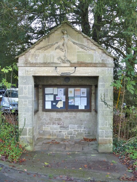
Image: © Michael Dibb Taken: 10 Dec 2020
At the junction of Higher Street and Shute Lane is this shelter containing notice boards built circa 1920 to a design by Giles Gilbert Scott. Known as 'The War Office', the shelter stems from the practice, established during World War I, of posting newspapers and telegraph bulletins on a board over the village pump for the information of villagers. It is now used as a general parish notice board. The shelter has rubble walls with stone dressings with a sculpted relief of Mercury with electric rays emanating from his hands representing the dissemination of news by wireless. Listed, grade II, with details at: https://historicengland.org.uk/listing/the-list/list-entry/1110196 Iwerne Minster is a small village on the edge of the Blackmore Vale, about 5 miles south of Shaftesbury and the same distance north of Blandford Forum. The village is within the Cranborne Chase and West Wiltshire Down Area of Outstanding Natural Beauty. There is evidence of occupation since prehistoric times. The River Iwerne flows from a spring in the middle of the village. The original Minister is now St Mary's Church and was built by the Normans on the site of an earlier church.
Images are licensed for reuse under creativecommons.org/licenses/by-sa/2.0
Image Location
Latitude
50.929884
Longitude
-2.191049