
St Giles House - South Terrace, Wimborne St Giles c.1970 (1)
Introduction
The photograph on this page of St Giles House - South Terrace, Wimborne St Giles c.1970 (1) by Ronald Searle as part of the Geograph project.
The Geograph project started in 2005 with the aim of publishing, organising and preserving representative images for every square kilometre of Great Britain, Ireland and the Isle of Man.

There are currently over 7.5m images from over 14,400 individuals and you can help contribute to the project by visiting https://www.geograph.org.uk
St Giles House - South Terrace, Wimborne St Giles c.1970 (1)
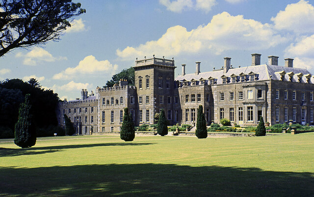
Image: © Ronald Searle Taken: Unknown
Appearances can be deceptive, as this mid-C17 house was in decline before this photo was taken, and by the time that restoration was commenced in 2010 was in a semi-ruinous state, and on the English Heritage "Buildings at Risk" register. During the years of neglect, and later during the 1970s, some demolition occurred as well as the destructive removal of 1820s render that badly damaged much of the brickwork. This render was evidently still in-situ when this photo was taken, as were substantial parts of the house that later underwent demolition. Looking at post-restoration pictures, it is the exposed brickwork (having since undergone significant repair) that is the most remarkable, the house now looking very much as it was in earlier times. It's not all good news however, as further comparisons reveal that some features of the South Terrace visible in this photo have since been lost. A case in point is the balustraded tower in the centre that is somewhat truncated today and without its balustrade! In addition, possibly the whole of the west wing extant here at this time has also gone: https://www.geograph.org.uk/photo/3582243 For photos of the restoration of the exterior in progress during 2012 see: https://www.geograph.org.uk/photo/2964947 Image
Images are licensed for reuse under creativecommons.org/licenses/by-sa/2.0
Image Location

Latitude
50.903685
Longitude
-1.95572