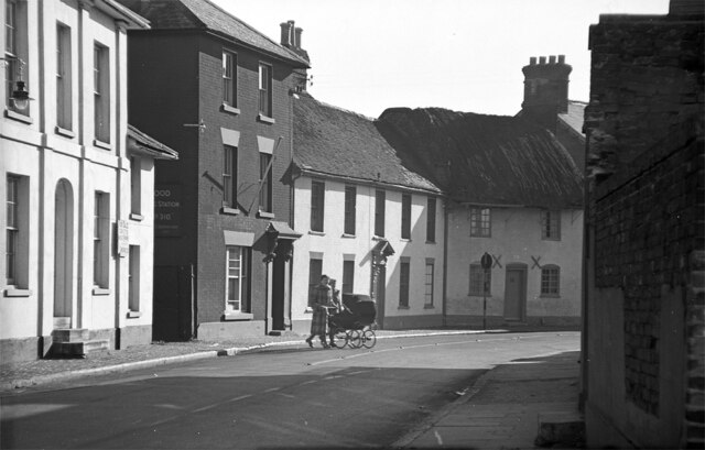
Christchurch Road - Ringwood c.1954 (1)
Introduction
The photograph on this page of Christchurch Road - Ringwood c.1954 (1) by Ronald Searle as part of the Geograph project.
The Geograph project started in 2005 with the aim of publishing, organising and preserving representative images for every square kilometre of Great Britain, Ireland and the Isle of Man.
There are currently over 7.5m images from over 14,400 individuals and you can help contribute to the project by visiting https://www.geograph.org.uk

Image: © Ronald Searle Taken: Unknown
The lack of road traffic is evident in this 1950s photo of Christchurch Road on this now busy street, where its junction with Hightown Road is just out of shot beyond the bend. The lady with the pram is more concerned with observing the photographer as she crosses the road, further demonstrating there was absolutely no danger of being mown down by road traffic at that time. The partially visible egg packing station sign on the side of the building to the left, is a reminder that the wartime governmental system of food distribution and rationing only ended in Britain in 1954. I should imagine the sign says "Ringwood Egg Packing Station No. 310". The next photo shows a similarly peaceful scene. Image

