The Court House, 7 Church Lane, Berkhamsted
Introduction
The photograph on this page of The Court House, 7 Church Lane, Berkhamsted by Jo and Steve Turner as part of the Geograph project.
The Geograph project started in 2005 with the aim of publishing, organising and preserving representative images for every square kilometre of Great Britain, Ireland and the Isle of Man.

There are currently over 7.5m images from over 14,400 individuals and you can help contribute to the project by visiting https://www.geograph.org.uk
The Court House, 7 Church Lane, Berkhamsted
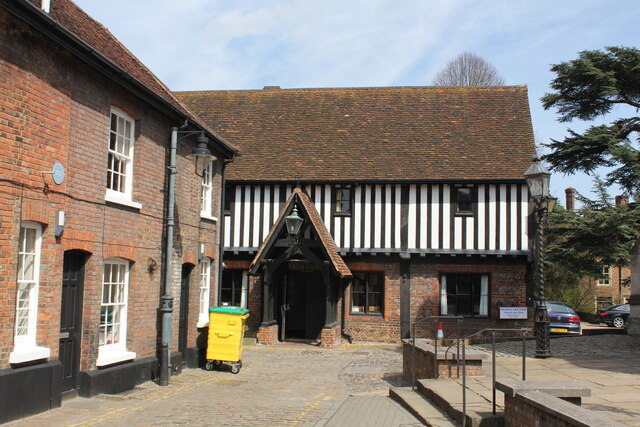
Image: © Jo and Steve Turner Taken: 21 Apr 2013
Much restored Grade II Listed 16th century building. The post-mote or borough court was held as far back as 1301 so possibly the Court is on the site of a mediaeval building. Formerly known as Church House or Town House it was built on waste land of the manor at the parishioners' expense and the ownership was long disputed. Held by the churchwardens on behalf of the parishioners in 1680 the Crown granted it to John Sayer. In 1761 the Manor was leased to the 3rd Duke of Bridgewater and his successors supportive of schools consented in 1838 to its use as a school and classrooms were built behind the Court House to become the home of the National School. Writing in 1855 Rev. J. W. Cobb tells us the courts of the Honour and Manor of Berkhamsted were still held twice a year here and it seems this is true into the 1880s. After litigation the Crown intervened again and it seems to be in 1863 Earl Brownlow of Ashridge bought the Manor that included the ownership of the Court House and immediately leased it at nominal rent back to the School until 1897. In the war of 1914-19 the Court House was used as an Orderly Room and in the 1918 flu epidemic an extension hospital. In the second war it was used to accommodate the surge in population due to evacuees from London schools. When the Victoria Schools were undergoing building works in the late 1960s and early 70s it was used as a dining hall after which it was restored. The Court House is now effectively the Church Hall for St Peter’s Church.
Images are licensed for reuse under creativecommons.org/licenses/by-sa/2.0
Image Location
Latitude
51.759818
Longitude
-0.56235