Bury St Edmunds buildings [80]
Introduction
The photograph on this page of Bury St Edmunds buildings [80] by Michael Dibb as part of the Geograph project.
The Geograph project started in 2005 with the aim of publishing, organising and preserving representative images for every square kilometre of Great Britain, Ireland and the Isle of Man.

There are currently over 7.5m images from over 14,400 individuals and you can help contribute to the project by visiting https://www.geograph.org.uk
Bury St Edmunds buildings [80]
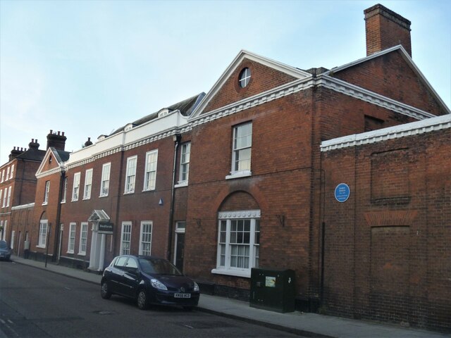
Image: © Michael Dibb Taken: 13 Sep 2020
This magnificent house, 81 and 82 Guildhall Street was used as offices for decades and was recently sold for possible re-conversion to a single dwelling. The mid 18th century central range was extended in the late 18th century with pedimented wings to each side. The wings were designed by the world-renowned architect John Soane. One wing was designed as a counting-house with a dining parlour for customers above and it became the premises of Bury & Suffolk Bank. To the rear is a 19th century building originally part of a yarn warehouse now converted to offices. The interior has some fine late 18th and early 19th century features. Listed, grade I, with details at: https://historicengland.org.uk/listing/the-list/list-entry/1363718 Guildhall Street is one of the north-south streets laid out in the 12th century. There is a rich mix of high quality buildings, especially at the commercial, northern end with a fine mix of houses at the residential, southern end. The Guildhall is a Norman building which is the oldest continuously used Civic building in the country. Bury St Edmunds is a market town which is the cultural and retail centre for West Suffolk and is known for brewing (Greene King) and sugar (British Sugar). There is scattered evidence of earlier activity but essentially Bury St Edmunds began as one of the royal boroughs of the Saxons and a monastery was founded which became the burial place of King Edmund. A new Benedictine abbey was built in 1020 which became rich and powerful and the town was laid out on a grid pattern by Abbot Baldwin. After the dissolution the abbey became ruinous. A new church, later the cathedral, was begun in the early 16th century.
Images are licensed for reuse under creativecommons.org/licenses/by-sa/2.0
Image Location
Latitude
52.243634
Longitude
0.71181