Gloucester buildings [11]
Introduction
The photograph on this page of Gloucester buildings [11] by Michael Dibb as part of the Geograph project.
The Geograph project started in 2005 with the aim of publishing, organising and preserving representative images for every square kilometre of Great Britain, Ireland and the Isle of Man.

There are currently over 7.5m images from over 14,400 individuals and you can help contribute to the project by visiting https://www.geograph.org.uk
Gloucester buildings [11]
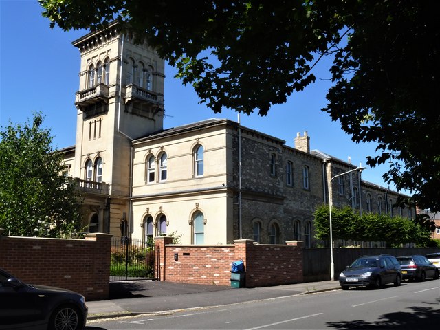
Image: © Michael Dibb Taken: 1 Jun 2020
Hillfield House in Denmark Road has an interesting history. Built in 1867 on the site of an 1820s villa, its grounds were all of Hillfield Gardens, now a public park. In the First World War it became an emergency war time hospital, then became a Church House after it was bought by the Diocese of Gloucester in the 1920’s. In 1933 it was acquired by Gloucester City Council and used as their local government offices until the 1970’s when it passed into the hands of the County Council. Recently sold back into private ownership it has been re-converted into a private dwelling and it was on the market (February 2020) for £1.85 million. The house has a number of features of historical interest including internal stone carvings, a Sicilian and black marble floor in the entrance hall and stained glass windows depicting the events in Gloucester during the War of the Barons. Listed, grade II, with details at: https://historicengland.org.uk/listing/the-list/list-entry/1271659 The cathedral city and county town of Gloucestershire, Gloucester lies on the River Severn and is linked via the Gloucester and Sharpness Canal to the river’s estuary. Founded by the Romans in AD 97, the city gained its first charter in 1155. In the Middle Ages there were a large number of monastic establishments including St Peter's Abbey founded in 679 - later Gloucester Cathedral. Until the construction of the Severn Bridge in 1966, Gloucester was the lowest road bridging point on the River Severn. The city has a long association with the aerospace business, including the Gloster Aircraft Company.
Images are licensed for reuse under creativecommons.org/licenses/by-sa/2.0
Image Location
Latitude
51.86989
Longitude
-2.229869