Redcliff Hill, looking north towards the Shot Tower
Introduction
The photograph on this page of Redcliff Hill, looking north towards the Shot Tower by Martin Tester as part of the Geograph project.
The Geograph project started in 2005 with the aim of publishing, organising and preserving representative images for every square kilometre of Great Britain, Ireland and the Isle of Man.

There are currently over 7.5m images from over 14,400 individuals and you can help contribute to the project by visiting https://www.geograph.org.uk
Redcliff Hill, looking north towards the Shot Tower
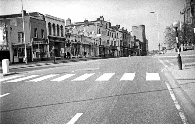
Image: © Martin Tester Taken: Unknown
This parade of shops ending at the Lead Shot Tower (Image) was swept away in 1969 to enable a dual carriageway to be driven through, so the scene is totally unrecognisable today. The road just glimpsed on the right is Prewett Street beyond which the west end of St Mary Redcliffe can be discerned. For a 2013 view see Image Date of photo uncertain, but 1966 or 1967.
Images are licensed for reuse under creativecommons.org/licenses/by-sa/2.0
Image Location


Leaflet Map data © OpenStreetMap
Latitude
51.448286
Longitude
-2.590658