Cheltenham features [6]
Introduction
The photograph on this page of Cheltenham features [6] by Michael Dibb as part of the Geograph project.
The Geograph project started in 2005 with the aim of publishing, organising and preserving representative images for every square kilometre of Great Britain, Ireland and the Isle of Man.

There are currently over 7.5m images from over 14,400 individuals and you can help contribute to the project by visiting https://www.geograph.org.uk
Cheltenham features [6]
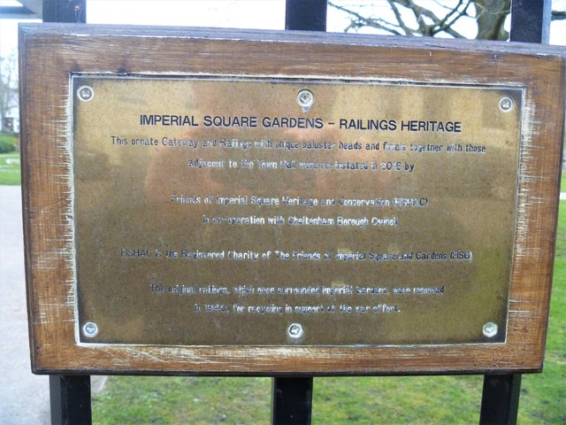
Image: © Michael Dibb Taken: 12 Mar 2020
This plaque is attached to railings in Imperial Square Gardens Image that were re-installed in 2016. The plaque reads: Imperial Square Gardens - Railings Heritage This ornate gateway and railings with unique baluster heads and finials together with those adjacent to the Town Hall were re-instated in 2016 by Friends of Imperial Square Heritage and Conservation (FISHAC) in co-operation with Cheltenham Borough Council FISHAC is the registered charity of The Friends of Imperial Square and Gardens (FISG) The original railings, which once surrounded Imperial Gardens, were removed in 1940 for recycling in support of the war effort. Cheltenham is located at the foot of the Cotswold scarp with the small River Chelt flowing through the town. After the discovery of mineral springs in 1716 Cheltenham became a spa town and many Regency houses and other buildings were erected. The town is home to the renowned Cheltenham Festival, four days of horse jump racing culminating in the Gold Cup, held annually in March at the nearby racecourse.
Images are licensed for reuse under creativecommons.org/licenses/by-sa/2.0
Image Location
Latitude
51.896162
Longitude
-2.078284