Thorpe-le-Soken: Former Thorpe maltings (1)
Introduction
The photograph on this page of Thorpe-le-Soken: Former Thorpe maltings (1) by Nigel Cox as part of the Geograph project.
The Geograph project started in 2005 with the aim of publishing, organising and preserving representative images for every square kilometre of Great Britain, Ireland and the Isle of Man.

There are currently over 7.5m images from over 14,400 individuals and you can help contribute to the project by visiting https://www.geograph.org.uk
Thorpe-le-Soken: Former Thorpe maltings (1)
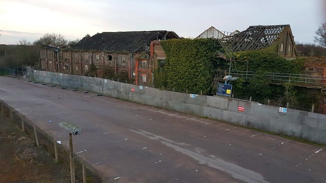
Image: © Nigel Cox Taken: 14 Mar 2020
This is the western half of the Grade II Listed former maltings, built around 1876. The building is in a dilapidated and parlous state, having markedly deteriorated further from the state it was in when Robert Edwards photographed it for Geograph in May 2007 Image This western half was used for the production of crystal malt and the eastern half Image] for pale malt, and no other maltings showing the double use of crystal and pale malt so distinctively are known to survive. This was photographed at dusk from the adjacent railway station footbridge.
Images are licensed for reuse under creativecommons.org/licenses/by-sa/2.0
Image Location
Latitude
51.848252
Longitude
1.160209