Part of the Information Board in Eton High Street (4)
Introduction
The photograph on this page of Part of the Information Board in Eton High Street (4) by David Hillas as part of the Geograph project.
The Geograph project started in 2005 with the aim of publishing, organising and preserving representative images for every square kilometre of Great Britain, Ireland and the Isle of Man.

There are currently over 7.5m images from over 14,400 individuals and you can help contribute to the project by visiting https://www.geograph.org.uk
Part of the Information Board in Eton High Street (4)
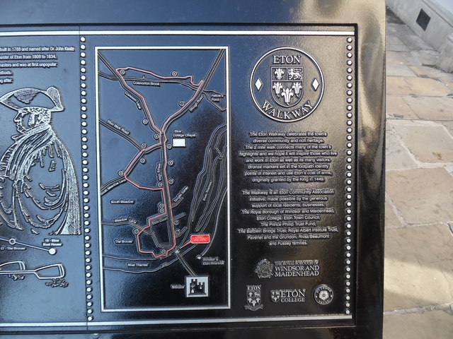
Image: © David Hillas Taken: 13 Sep 2019
The sixth and seventh columns have the following illustration and wording: Map of the Eton Walkway This map shows the following eighteen locations: 1) The King's Stables 2) The Cockpit 3) Eton Pony School 4) Baldwin's Bridge 5) Eton College 6) The Burning Bush 7) The Wall Game 8) Skinner's Bridge 9) The Herschel Observatory 10) Sir Antony Gormley's Edge II Statue 11) Keate House 12) The Natural History Museum 13) Eton Museum of Antiquities 14) The Church of St John the Evangelist 15) The Christopher Inn 16) Jubilee Square 17) The Brocas 18) Eton Boat House Nos 2, 5, 10,11,12 and 18 are described on this information board https://www.geograph.org.uk/photo/6396908, https://www.geograph.org.uk/photo/6396927 refer. Wording to the right of the Map The Eton Walkway celebrates the town's diverse community and rich heritage. The 2 mile walk connects many of the town's highlights and we hope it will inspire those who live and work in Eton as well as its many visitors. Bronze markers set in the footpath identify points of interest and use Eton's coat of arms, originally granted by the King in 1449. The Walkway is an Eton Community Association initiative, made possible by the generous support of local residents, businesses, The Royal Borough of Windsor and Maidenhead, Eton College, Eton Town Council, The Prince Philip Trust Fund, The Baldwin Bridge Trust, Royal Albert Institute Trust, Pavenet and the Grundon, Rivaz/Beaumont and Fussey families.
Images are licensed for reuse under creativecommons.org/licenses/by-sa/2.0
Image Location
Latitude
51.486126
Longitude
-0.608853