River Cray alongside Mill Brook Road
Introduction
The photograph on this page of River Cray alongside Mill Brook Road by Marathon as part of the Geograph project.
The Geograph project started in 2005 with the aim of publishing, organising and preserving representative images for every square kilometre of Great Britain, Ireland and the Isle of Man.

There are currently over 7.5m images from over 14,400 individuals and you can help contribute to the project by visiting https://www.geograph.org.uk
River Cray alongside Mill Brook Road
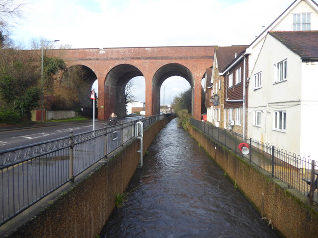
Image: © Marathon Taken: 13 Feb 2020
John Newman in Pevsner's 'The Buildings of England: West Kent and the Weald' writing in 1969 was fairly scathing about St Mary Cray. He wrote: "The post-war expansion in the Cray Valley has been terrific... So it is an indictment of the planners that St Mary Cray is no place to linger in, and an indictment of the architects, and also it must be admitted of post-war austerity, that there is hardly anything worthy to be mentioned in 'The Buildings of England'; not a factory, not a school, not a housing estate, just one undistinguished church." Of the church he says: "Below the intimidating arches of the railway viaduct. Outside all one sees is of the restoration of 1861-3 (E. Nash), 1876 and 1895. ..But in essence the church is early 13th century. West tower and shingled spire. Nave and aisles of three bays." This view looks downriver to where the River Cray flows underneath St Mary Cray viaduct which is here between St Mary Cray and Swanley stations. The viaduct was built in 1860 for the London, Chatham & Dover Railway. On the right is what was the Mary Rose Hotel which has now been renamed The Pavilion.
Images are licensed for reuse under creativecommons.org/licenses/by-sa/2.0
Image Location
Latitude
51.394381
Longitude
0.114273