Wartime Ardleigh WW1 1914-18, WW2 1939-45
Introduction
The photograph on this page of Wartime Ardleigh WW1 1914-18, WW2 1939-45 by Adrian S Pye as part of the Geograph project.
The Geograph project started in 2005 with the aim of publishing, organising and preserving representative images for every square kilometre of Great Britain, Ireland and the Isle of Man.

There are currently over 7.5m images from over 14,400 individuals and you can help contribute to the project by visiting https://www.geograph.org.uk
Wartime Ardleigh WW1 1914-18, WW2 1939-45
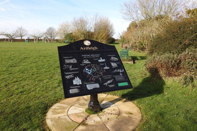
Image: © Adrian S Pye Taken: 14 Feb 2020
The plaque which is located beside a path on the playing field illustrates thirteen different aspects of village life in the War Years. Top left is the school which billeted troops in WW1 and the children who were evacuated in WW2. Below that a USAAF Thunderbolt which crashed at Wick Farm killing the pilot, 2lt Samuel K. Batson, age 22, is remembered. Below that, the aircraft factory at Blue Barns and the grass landing strip together with the WW2 USAAF airfield at Langham and the Crown public house where the airmen used to enjoy a tipple. At the bottom is an illustration of a pillbox of which there were two in the village. Above the map, left of centre are the two AA batteries and searchlights. To the right, the Vicar's Rooms are remembered as being a Red Cross, VAD Hospital. Immediately below is a representation of the War Memorial. Below the map on the left, the Mobile Hospital Unit is represented, having been based at Collierswood Farm in WW2. To the right a V1 "doodlebug" which killed four people including two young girls in 1944 is not forgotten. Top right, The Newth Hall where the Red Cross held fund-raising events in WW1 and used by the Home Guard as their Headquarters in WW2. Below that is the Old King's Head, now renamed Ancient House was commandeered in WW1 as The War Work Depot. Finally, bottom right is a memorial to the seven crew of 102 Squadron, RAF Halifax II, DT800-DY-P which had taken off from Pocklington and crashed at Badliss Hall, on 25th of February 1943.
Images are licensed for reuse under creativecommons.org/licenses/by-sa/2.0
Image Location
Latitude
51.923417
Longitude
0.983835