Cirencester houses [16]
Introduction
The photograph on this page of Cirencester houses [16] by Michael Dibb as part of the Geograph project.
The Geograph project started in 2005 with the aim of publishing, organising and preserving representative images for every square kilometre of Great Britain, Ireland and the Isle of Man.

There are currently over 7.5m images from over 14,400 individuals and you can help contribute to the project by visiting https://www.geograph.org.uk
Cirencester houses [16]
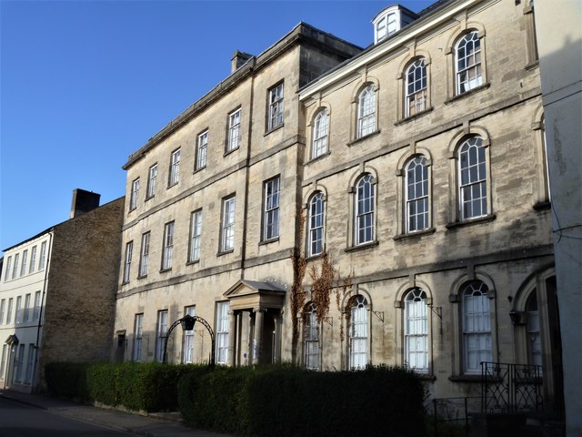
Image: © Michael Dibb Taken: 24 Sep 2019
Number 30 Dollar Street (nearest the camera) and number 32 Dollar Street were together formerly known as Dollar Street House. Number 30 is dated 1725, number 32 is early 19th century. Constructed of ashlar to the front and coursed squared limestone to the rear under Welsh slate roofs. Now used as offices, the houses contain some fine internal features, some original. There is another image of the houses at Image Listed, grade II*, with details at: https://historicengland.org.uk/listing/the-list/list-entry/1280530 Cirencester, the largest town in the Cotswolds, is a market town some 15 miles south east of Gloucester and some 13 miles north west of Swindon. The town lies on the River Churn, a tributary of the River Thames and is the hub of a network of roads. It is the home of the Royal Agricultural University, founded in 1840. An important Roman settlement known as Corinium, the town, with 240 acres enclosed by walls was second only to London in size.
Images are licensed for reuse under creativecommons.org/licenses/by-sa/2.0
Image Location
Latitude
51.719242
Longitude
-1.969988