Coal tax boundary post no.49, Oxhey Lane
Introduction
The photograph on this page of Coal tax boundary post no.49, Oxhey Lane by Mike Quinn as part of the Geograph project.
The Geograph project started in 2005 with the aim of publishing, organising and preserving representative images for every square kilometre of Great Britain, Ireland and the Isle of Man.

There are currently over 7.5m images from over 14,400 individuals and you can help contribute to the project by visiting https://www.geograph.org.uk
Coal tax boundary post no.49, Oxhey Lane
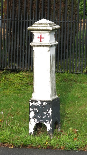
Image: © Mike Quinn Taken: 9 Oct 2019
The location of this post is shown in Image and Image This base of post is some way out of the ground, revealing the "legs" of the casting, but Image shows that there is still a fair amount of the post below ground level. The pot is Grade II listed https://historicengland.org.uk/listing/the-list/list-entry/1193954 . There were originally nearly 280 coal tax posts located around London, of which about 210 are still extant; around 180 of these (85%) are 3 ft high white-painted square bollards with a pyramidal top, decorative raised bands, and the shield from the City of London’s arms, like this one. Photos of the coal tax posts on Geograph are at http://www.geograph.org.uk/search.php?i=86542993&page=1 . The posts were erected under the Coal and Wine Duties (Continuation) Act of 1861 to mark the points at which duty had to be paid on coal being transported to London. The boundary was set at that of the Metropolitan Police District, and the resulting revenue was used by the Corporation of the City of London to fund public works. For further info see http://www.coaldutyposts.org.uk/cityposts.html . This post is Grade II listed - it's so good, it's listed twice (at very slightly different grid references): https://historicengland.org.uk/listing/the-list/list-entry/1193954 and https://historicengland.org.uk/listing/the-list/list-entry/1347904 . The first of the listings (which has a minimal text) has a photo of the post (in 1999) when the horizontal bands above and below the City of London crest were painted black, and the base was painted white. The second listing says "... Raised panel on front face of shaft has raised lettering 'Act 24 and 25 Vict. Cap 42'". This implies that at the time the listing was drawn up there was a correction plate, as the original inscription did not include "ACT". Although there is no trace of the original inscription (which must have been completely ground off when the correction plate was fitted) there is what looks to be one of the holes for the fixing of the correction plate: this would have been below the "C" of "CAP" in the second line of the inscription - see Image, Image and Image
Images are licensed for reuse under creativecommons.org/licenses/by-sa/2.0
Image Location
Latitude
51.620604
Longitude
-0.368128