Cenacle Convent, Alexandra Road, Whalley Range
Introduction
The photograph on this page of Cenacle Convent, Alexandra Road, Whalley Range by Tom Jolliffe as part of the Geograph project.
The Geograph project started in 2005 with the aim of publishing, organising and preserving representative images for every square kilometre of Great Britain, Ireland and the Isle of Man.

There are currently over 7.5m images from over 14,400 individuals and you can help contribute to the project by visiting https://www.geograph.org.uk
Cenacle Convent, Alexandra Road, Whalley Range
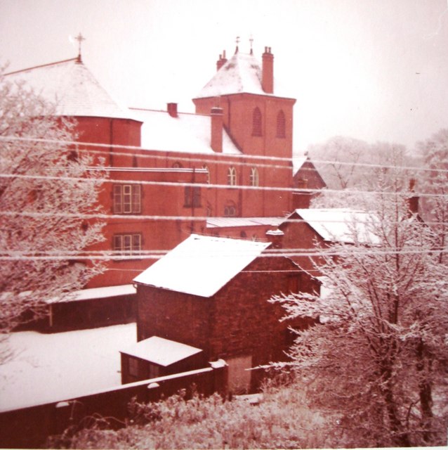
Image: © Tom Jolliffe Taken: Unknown
The Cenacle convent building was based on a French design with a large bell tower. The convent was originally designed to be more or less self sufficient, with large grounds containing fruit trees, greenhouses, poultry sheds, etc. Economic considerations led to the building being demolished in the 1970s, leaving the order running a retreat house on the site. Some of the other buildings were used by the St Bede's College nearby and later large parts of the grounds were sold. A housing development was built on this in about 2006. This photo was taken from the house at 7 Wellington Road, which has now been demolished. Also see Image] Image] Had this convent survived into the 1990s, I feel sure that it would have been converted into architect designed apartments. The ones in the bell tower would have had immense views. A church not far away from here - St Edmunds - opposite to Alexandra Park, now houses many unique apartments. And St Edmunds was not in the same architectural league as the Cenacle Convent. Also see Image] and Image]
Images are licensed for reuse under creativecommons.org/licenses/by-sa/2.0
Image Location
Latitude
53.450233
Longitude
-2.252927