
WWII Staffordshire: RAF Tatenhill - technical site - combined AML Bombing Teacher & Turret Gunnery Trainer (1)
Introduction
The photograph on this page of WWII Staffordshire: RAF Tatenhill - technical site - combined AML Bombing Teacher & Turret Gunnery Trainer (1) by Mike Searle as part of the Geograph project.
The Geograph project started in 2005 with the aim of publishing, organising and preserving representative images for every square kilometre of Great Britain, Ireland and the Isle of Man.

There are currently over 7.5m images from over 14,400 individuals and you can help contribute to the project by visiting https://www.geograph.org.uk
WWII Staffordshire: RAF Tatenhill - technical site - combined AML Bombing Teacher & Turret Gunnery Trainer (1)
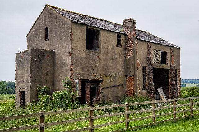
Image: © Mike Searle Taken: 23 Jun 2019
It was usual for bombing and gunnery training to be conducted in separate dedicated buildings rather than combining them as here, under one roof. The building is in two halves, the LH end was for the Air Ministry Laboratory Bombing Teacher, the RH end the Turret Gunnery Trainer. The airfield at RAF Tatenhill (which is still in use today as a private flying club) was constructed in 1941 as an RLG for RAF Burnaston, and later as a satellite of 27 OTU RAF Lichfield, flying Wellingtons and Avro Ansons on night-bomber training. After the airfield was later considered unsuitable for Wellingtons, it was placed into Care & Maintenance until November 1942 when it was loaned as a Flying Training Unit to 15 (P) AFU equipped with Airspeed Oxfords. Further role changes occurred with the departure of 15 (P) AFU and the arrival of 'E' Flight of 5 (P) AFU who flew from Tatenhill with Miles Masters specialising in navigation and night flying training from 1943 - 1944. From January 1944 the airfield came under 21 (P) AFU, again with Airspeed Oxfords. From 1944 after the RAF Fauld explosives disaster it was the home of 21 MU, and from 1945-47 the RAF School of Explosives. The airfield was closed for military use in 1947. Image
Images are licensed for reuse under creativecommons.org/licenses/by-sa/2.0
Image Location

Latitude
52.818785
Longitude
-1.76017