The Soho Foundry building
Introduction
The photograph on this page of The Soho Foundry building by Richard Law as part of the Geograph project.
The Geograph project started in 2005 with the aim of publishing, organising and preserving representative images for every square kilometre of Great Britain, Ireland and the Isle of Man.

There are currently over 7.5m images from over 14,400 individuals and you can help contribute to the project by visiting https://www.geograph.org.uk
The Soho Foundry building
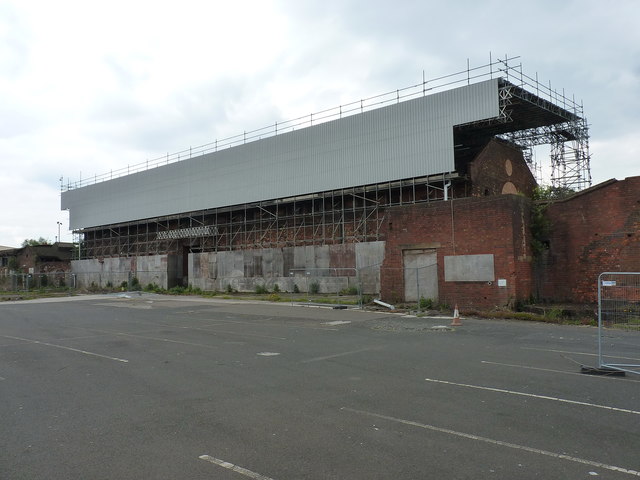
Image: © Richard Law Taken: 20 May 2019
Currently covered & protected by this large 'scaffold & cladding' construction, The Soho Foundry is arguably one of the West Mids' most important industrial heritage locations. The yard in which it stands is a Scheduled Ancient Monument, proven by excavations in the very early 21st century to contain extensive buried remains of a series of foundries, pattern stores, foundry stores, boring mill etc. All are associated with the site which was developed around 1796 by Matthew Boulton & James Watt, manufacturers of steam engines for assorted purposes. These included, in the 1850s, the engines for the SS Great Britain, Isambard Kingdom Brunel's ship which started life as a passenger liner, but later laid the first transatlantic telecommunications cable in 1866. The foundry building itself, here under its protective cover, is hard to access, as it lies within the yard of WT Avery, makers of modern weighbridges and smaller-scale weighing machines; they are understandably reluctant to let the public on site, never mind wander willy-nilly around the old building. It was Grade II* listed https://britishlistedbuildings.co.uk/101268451-soho-foundry-former-boulton-and-watt-foundry-pattern-stores-and-erecting-shops-soho-and-victoria-ward#.XRjVY-hKjcs & https://historicengland.org.uk/listing/the-list/list-entry/1268451 in 1996.
Images are licensed for reuse under creativecommons.org/licenses/by-sa/2.0
Image Location
Latitude
52.497456
Longitude
-1.951053