C?te de Grosmont
Introduction
The photograph on this page of C?te de Grosmont by Mick Garratt as part of the Geograph project.
The Geograph project started in 2005 with the aim of publishing, organising and preserving representative images for every square kilometre of Great Britain, Ireland and the Isle of Man.

There are currently over 7.5m images from over 14,400 individuals and you can help contribute to the project by visiting https://www.geograph.org.uk
C?te de Grosmont
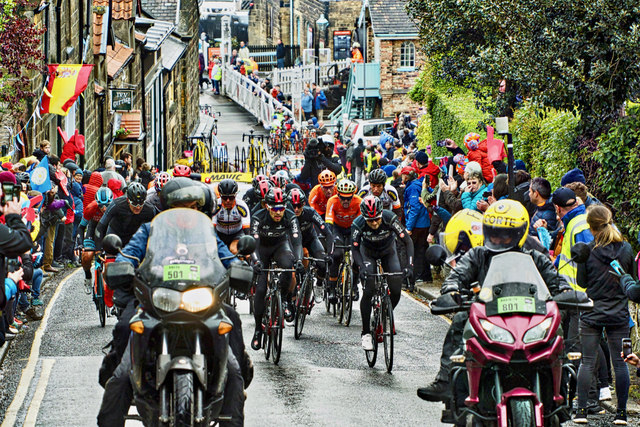
Image: © Mick Garratt Taken: 4 May 2019
A trip out to watch the Tour de Yorkshire. By the time the riders began the 4th Classified Climb at Grosmont, there was a break in the showers. The “Côte de Grosmont” is not long, only 500m but a gradient of 15% makes it a tough little climb. Amid a cacophony, Team INEOS, in their rather drab colours, are seen here setting the pace. INEOS is a controversial sponsor. It is one of the companies that hold fracking licences to extract shale gas from under Yorkshire. Fracking is claimed can cause air and groundwater pollution, contribute to the greenhouse gas emissions, and can trigger earthquakes. From my photo-diary for 4th May 2019 see http://www.fhithich.uk/?p=21106
Images are licensed for reuse under creativecommons.org/licenses/by-sa/2.0
Image Location


Leaflet Map data © OpenStreetMap
Latitude
54.435644
Longitude
-0.723284