New Street, The Barbican, Plymouth
Introduction
The photograph on this page of New Street, The Barbican, Plymouth by David Hallam-Jones as part of the Geograph project.
The Geograph project started in 2005 with the aim of publishing, organising and preserving representative images for every square kilometre of Great Britain, Ireland and the Isle of Man.

There are currently over 7.5m images from over 14,400 individuals and you can help contribute to the project by visiting https://www.geograph.org.uk
New Street, The Barbican, Plymouth
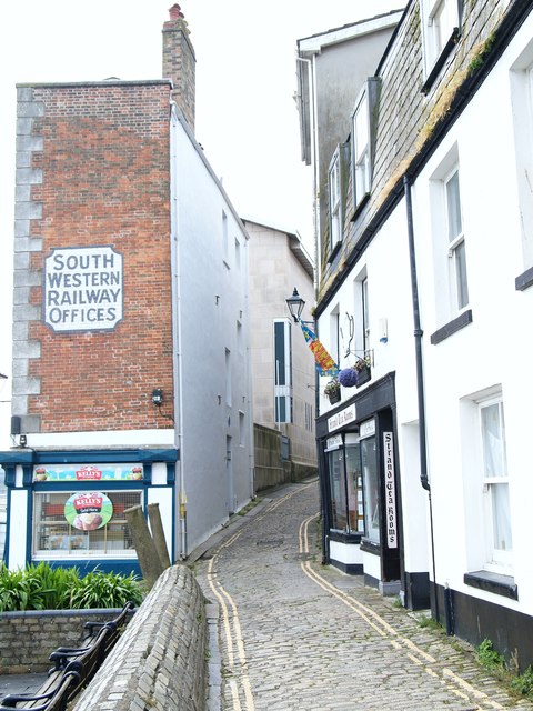
Image: © David Hallam-Jones Taken: 17 Apr 2019
The southern-most end of New Street, uphill towards Castle Street. Although originally named Greyfriars Street, New Street was later renamed Rag Lane. The present day New Street was laid out in the early C16th century by local merchant and entrepreneur named John Sparke, the first Englishman to use and document the South American words 'potatoes' and ‘tobacco'. The London & South Western Railway’s services reached Sutton Harbour (i.e. Sutton Jetty) at The Barbican in 1878, hence the use of this building as a “Receiving Office for Incoming Goods”. Sutton Harbour - not visible here but to the left of this image - remained Plymouth’s main commercial port until the 1840s. However, by the mid-C19th New Street’s fortunes had diminished. The building on the right, now housing the Tudor Rose Tea Rooms, is thought to have been built as merchant's house in the late C17th. The frontage however, has been modernised. The Barbican Theatre in Castle Street lies ahead. The city council bought the theatre (then “Serenade Arts”) in 1986 as a base for a local youth theatre company, although it is now run as a charitable trust.
Images are licensed for reuse under creativecommons.org/licenses/by-sa/2.0
Image Location


Leaflet Map data © OpenStreetMap
Latitude
50.366652
Longitude
-4.134661