Old Milestone by the A429, Kemble Road, Chelworth Lawns
Introduction
The photograph on this page of Old Milestone by the A429, Kemble Road, Chelworth Lawns by M Faherty as part of the Geograph project.
The Geograph project started in 2005 with the aim of publishing, organising and preserving representative images for every square kilometre of Great Britain, Ireland and the Isle of Man.

There are currently over 7.5m images from over 14,400 individuals and you can help contribute to the project by visiting https://www.geograph.org.uk
Old Milestone by the A429, Kemble Road, Chelworth Lawns
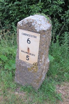
Image: © M Faherty Taken: 3 Oct 2010
Plastic plate attached to stone post by the A429, in parish of Crudwell (North Wiltshire District), Kemble Road, Chelworth Lawns; 200m North of Chelworth turn, on the verge, on East side of road. Malmesbury First plate, erected by the Malmesbury - First District turnpike trust in the 19th century. Inscription reads:- CIRENCESTER 6 MALMESBURY 5 Carved benchmark below plate. Grade II listed. List Entry Number: 1181775 https://historicengland.org.uk/listing/the-list/list-entry/1181775 Milestone Society National ID: WI_MYCI05
Images are licensed for reuse under creativecommons.org/licenses/by-sa/2.0
Image Location
Latitude
51.648641
Longitude
-2.05791