Old Wayside Cross north of Tinpark Farm, Cornwood parish
Introduction
The photograph on this page of Old Wayside Cross north of Tinpark Farm, Cornwood parish by Alan Rosevear as part of the Geograph project.
The Geograph project started in 2005 with the aim of publishing, organising and preserving representative images for every square kilometre of Great Britain, Ireland and the Isle of Man.

There are currently over 7.5m images from over 14,400 individuals and you can help contribute to the project by visiting https://www.geograph.org.uk
Old Wayside Cross north of Tinpark Farm, Cornwood parish
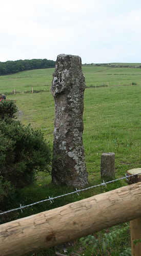
Image: © Alan Rosevear Taken: 18 Jun 2010
Ridding Down (Cholwich Town Farm) Cross, old head and shaft, by the UC road, in parish of Cornwood (South Hams District), Tinpark Farm stables, Ridding Down (opposite entrance to Cholwich Town Farm), in a paddock, to North of farm, 5m from roadside. Grade II listed. List Entry Number: 1325395 https://historicengland.org.uk/listing/the-list/list-entry/1325395 Scheduled Monument. List Entry Number: 1008931 https://historicengland.org.uk/listing/the-list/list-entry/1008931 Surveyed Milestone Society National ID: DVSH_COR01
Images are licensed for reuse under creativecommons.org/licenses/by-sa/2.0
Image Location
Latitude
50.433439
Longitude
-3.992003