Antonine Wall
Introduction
The photograph on this page of Antonine Wall by Mick Garratt as part of the Geograph project.
The Geograph project started in 2005 with the aim of publishing, organising and preserving representative images for every square kilometre of Great Britain, Ireland and the Isle of Man.

There are currently over 7.5m images from over 14,400 individuals and you can help contribute to the project by visiting https://www.geograph.org.uk
Antonine Wall
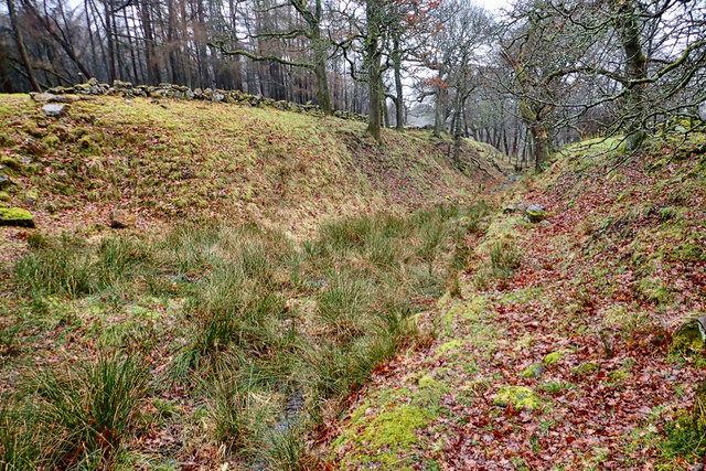
Image: © Mick Garratt Taken: 6 Mar 2019
A huge ditch gives some idea of the scale of the engineering the Romans put into the building of the Antonine Wall. Stretching 40 miles across Scotland between the Clyde and the Forth estuaries, it was built of the orders of the Emperor Antoninus Pius in AD 142 and occupied for 22 years before being abandoned with a retreat back to Hadrian’s Wall with a brief reoccupation in the early 3rd century. Unlike Hadrian’s Wall, the Antonine Wall was not built of stone but of turf. This 3-4 metre high turf wall would have been on the line of the Victorian stone wall on the far bank. This view is looking west so any infiltration would come from the right. The turf wall would have been topped by a wooden palisade. Of course, the military zone would have been cleared of trees. This well-preserved section of the wall is at Dullatur on a very dreich morning. From my photo-diary http://www.fhithich.uk/?p=20889
Images are licensed for reuse under creativecommons.org/licenses/by-sa/2.0
Image Location
Latitude
55.972206
Longitude
-3.997902