Old Milepost by the A4110, Gotherment, Wigmore parish
Introduction
The photograph on this page of Old Milepost by the A4110, Gotherment, Wigmore parish by Robert Walker as part of the Geograph project.
The Geograph project started in 2005 with the aim of publishing, organising and preserving representative images for every square kilometre of Great Britain, Ireland and the Isle of Man.

There are currently over 7.5m images from over 14,400 individuals and you can help contribute to the project by visiting https://www.geograph.org.uk
Old Milepost by the A4110, Gotherment, Wigmore parish
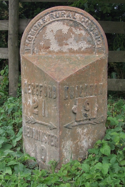
Image: © Robert Walker Taken: 31 Oct 2011
Cast iron post by the A4110, in parish of WIGMORE (District), Gotherment, by the road, on East side of road. Wigmore iron headed casting, erected by the District Council in the 19th/20th century. Inscription reads:- : HEREFORD / 21 / {arrow->} / LEOMINSTER / 10 : : WIGMORE RURAL DISTRICT : : KNIGHTON / 9 / {<-arrow} : Herefordshire SMR. SMR Number: 56626 https://www.heritagegateway.org.uk/Gateway/Results_Single.aspx?uid=MHE28382&resourceID=101 Milestone Society National ID: HF_HFKN21.
Images are licensed for reuse under creativecommons.org/licenses/by-sa/2.0
Image Location


Leaflet Map data © OpenStreetMap
Latitude
52.323531
Longitude
-2.867467