Old Boundary Marker by the B6108, Huddersfield Road, Meltham
Introduction
The photograph on this page of Old Boundary Marker by the B6108, Huddersfield Road, Meltham by Milestone Society as part of the Geograph project.
The Geograph project started in 2005 with the aim of publishing, organising and preserving representative images for every square kilometre of Great Britain, Ireland and the Isle of Man.

There are currently over 7.5m images from over 14,400 individuals and you can help contribute to the project by visiting https://www.geograph.org.uk
Old Boundary Marker by the B6108, Huddersfield Road, Meltham
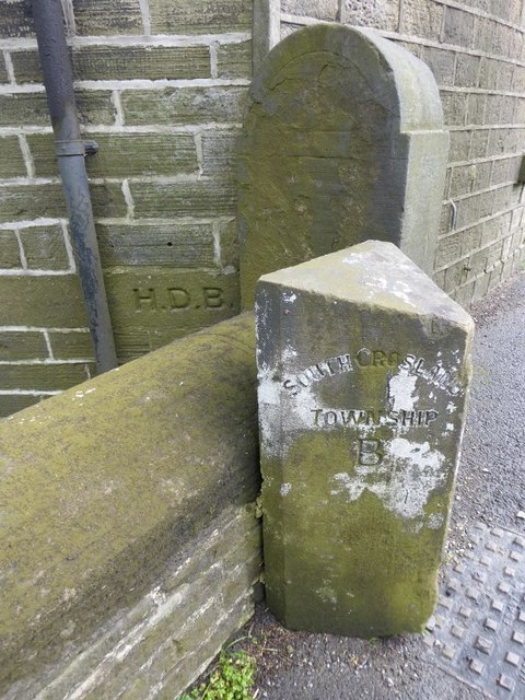
Image: © Milestone Society Taken: Unknown
Municipal Boundary Marker by the B6108, in parish of Meltham (Kirklees District), Huddersfield Road, Bent Ley Mills: the boundary (until 1938) between South Crosland and Meltham townships - now all in Meltham. On the building behind, the letters HDB stand for Helme District Boundary, denoting the boundary of the Helme Chapelry, established in 1858. Inscriptions read:- : SOUTH CROSLAND / TOWNSHIP / B : : MELTHAM / TOWNSHIP / B : : H.D.B. : Grade II listed:- List Entry Number: 1134660 https://historicengland.org.uk/listing/the-list/list-entry/1134660 Surveyed Milestone Society National ID: YW_HDB01pb
Images are licensed for reuse under creativecommons.org/licenses/by-sa/2.0
Image Location
Latitude
53.597843
Longitude
-1.835838