Old Boundary Marker by the B4314, Tavernspite
Introduction
The photograph on this page of Old Boundary Marker by the B4314, Tavernspite by Milestone Society as part of the Geograph project.
The Geograph project started in 2005 with the aim of publishing, organising and preserving representative images for every square kilometre of Great Britain, Ireland and the Isle of Man.

There are currently over 7.5m images from over 14,400 individuals and you can help contribute to the project by visiting https://www.geograph.org.uk
Old Boundary Marker by the B4314, Tavernspite
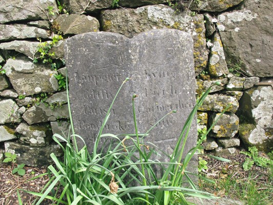
Image: © Milestone Society Taken: Unknown
County Boundary Marker by the B4314, in parish of Lampeter Velfrey (Pembrokeshire District), Tavernspite, in front of the garden wall of Mile End House next to milestone: PEM_CMNB16 Image Inscription reads:- Left face: : Lanpeter / felffre / Parish / Pembroke / shire : Right face: : Kyffig / Parish / Carmarthen / shire : Carved bench mark on lower right face. Grade II listed by Cadw. Reference Number: 18986 https://cadwpublic-api.azurewebsites.net/reports/listedbuilding/FullReport?lang=&id=18986 Surveyed Milestone Society National ID: PEM_CMNB16cb
Images are licensed for reuse under creativecommons.org/licenses/by-sa/2.0
Image Location


Leaflet Map data © OpenStreetMap
Latitude
51.782876
Longitude
-4.637238