Old Milestone by the A696
Introduction
The photograph on this page of Old Milestone by the A696 by IA Davison as part of the Geograph project.
The Geograph project started in 2005 with the aim of publishing, organising and preserving representative images for every square kilometre of Great Britain, Ireland and the Isle of Man.

There are currently over 7.5m images from over 14,400 individuals and you can help contribute to the project by visiting https://www.geograph.org.uk
Old Milestone by the A696
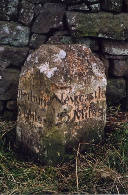
Image: © IA Davison Taken: 1 Apr 2005
Carved stone post by the A696, in parish of ELSDON (ALNWICK District), Ottercops, 400m Northwest of Ottercops Road End, in verge against stone wall to left of gate, on South side of road. Newcastle quadrant stone, erected by the Elsdon & Rudwater turnpike trust in the 19th century. Inscription reads:- : OTTERBURN / 5 MILES / JEDBURGH / 31 MILES : : NEWCASTLE / 25 MILES : Grade II listed. List Entry Number: 1041270 https://historicengland.org.uk/listing/the-list/list-entry/1041270 Milestone Society National ID: NB_NCJB25.
Images are licensed for reuse under creativecommons.org/licenses/by-sa/2.0
Image Location


Leaflet Map data © OpenStreetMap
Latitude
55.19415
Longitude
-2.075244