Old Milestone by the A635, Greenfield Road, Holmfirth
Introduction
The photograph on this page of Old Milestone by the A635, Greenfield Road, Holmfirth by C Minto as part of the Geograph project.
The Geograph project started in 2005 with the aim of publishing, organising and preserving representative images for every square kilometre of Great Britain, Ireland and the Isle of Man.

There are currently over 7.5m images from over 14,400 individuals and you can help contribute to the project by visiting https://www.geograph.org.uk
Old Milestone by the A635, Greenfield Road, Holmfirth
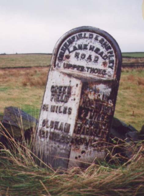
Image: © C Minto Taken: 25 Sep 2002
Metal plate attached to stone post by the A635, in parish of HOLME VALLEY (KIRKLEES District), Greenfield Road, Upperthong, Holmfirth, West of Greengate Road; opposite iron gate and cream house, near telegraph pole EP5a, by the South side of road. Brayshaw & Booth iron casting, erected by the County Council in the 19th century. Inscription reads:- : GREEN / FIELD / 8½ MILES / OLDHAM / 12¾ MILES : : GREENFIELD & SHEPLEY / LANE HEAD / ROAD / UPPERTHONG : : HOLMFIRTH / 2 MILES / BARNSLEY / 16 MILES : Maker:- : BRAYSHAW & BOOTH / MAKERS / LIVERSEDGE : Grade II Listed. List Entry Number: 1313569 https://historicengland.org.uk/listing/the-list/list-entry/1313569 Milestone Society National ID: YW_GFSLH08.
Images are licensed for reuse under creativecommons.org/licenses/by-sa/2.0
Image Location
Latitude
53.571009
Longitude
-1.832846