Old Milestone by the A548, Llanfair Talhaiarn
Introduction
The photograph on this page of Old Milestone by the A548, Llanfair Talhaiarn by Milestone Society as part of the Geograph project.
The Geograph project started in 2005 with the aim of publishing, organising and preserving representative images for every square kilometre of Great Britain, Ireland and the Isle of Man.

There are currently over 7.5m images from over 14,400 individuals and you can help contribute to the project by visiting https://www.geograph.org.uk
Old Milestone by the A548, Llanfair Talhaiarn
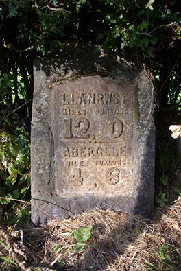
Image: © Milestone Society Taken: Unknown
By the A548, in parish of Llanfair Talhaiarn (Conwy County Borough District), Llanfair Talhaiarn. Inscription reads:- LLANRWST MILES FURLONGS 12. 0 ABERGELE MILES FURLONGS 4 . 6 Grade II listed by Cadw. Reference Number 20158: https://cadwpublic-api.azurewebsites.net/reports/listedbuilding/FullReport?lang=&id=20158 To be surveyed Milestone Society National ID: DEN_LRAG12
Images are licensed for reuse under creativecommons.org/licenses/by-sa/2.0
Image Location
Latitude
53.219127
Longitude
-3.608971