Old Wayside Cross by the B3212, Six Mile Hill, Dunsford Parish
Introduction
The photograph on this page of Old Wayside Cross by the B3212, Six Mile Hill, Dunsford Parish by Alan Rosevear as part of the Geograph project.
The Geograph project started in 2005 with the aim of publishing, organising and preserving representative images for every square kilometre of Great Britain, Ireland and the Isle of Man.

There are currently over 7.5m images from over 14,400 individuals and you can help contribute to the project by visiting https://www.geograph.org.uk
Old Wayside Cross by the B3212, Six Mile Hill, Dunsford Parish
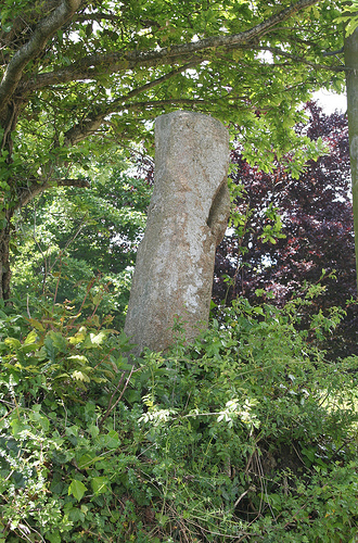
Image: © Alan Rosevear Taken: 26 May 2009
Six Mile Hill Cross, old shaft by the B3212, in parish of Dunsford (Teignbridge District), Two Crosses, Six Mile Hill, high on a bank above the crossroads, South West angle of junction. Grade II listed. List Entry Number: 1215569 https://historicengland.org.uk/listing/the-list/list-entry/1215569 Surveyed Milestone Society National ID: DVTE_DUF01.
Images are licensed for reuse under creativecommons.org/licenses/by-sa/2.0
Image Location
Latitude
50.692517
Longitude
-3.660402