Old Direction Sign - Signpost, north of Greystoke village
Introduction
The photograph on this page of Old Direction Sign - Signpost, north of Greystoke village by M Rayner as part of the Geograph project.
The Geograph project started in 2005 with the aim of publishing, organising and preserving representative images for every square kilometre of Great Britain, Ireland and the Isle of Man.

There are currently over 7.5m images from over 14,400 individuals and you can help contribute to the project by visiting https://www.geograph.org.uk
Old Direction Sign - Signpost, north of Greystoke village
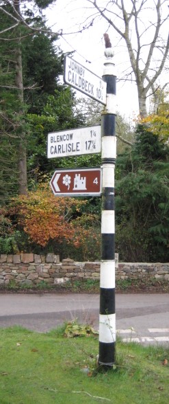
Image: © M Rayner Taken: 13 Nov 2017
Pawn finial - 2 arms; Cumberland CC square end by the UC road, in parish of Greystoke (Eden District), road junction North of Greystoke village. Restored by Terry Moore in 2022 with an arm to Greystoke and Penrith replaced, see https://www.geograph.org.uk/photo/7259792. Surveyed Milestone Society National ID: CU_NY4331.
Images are licensed for reuse under creativecommons.org/licenses/by-sa/2.0
Image Location
Latitude
54.673146
Longitude
-2.870959