The Kings Cross Labyrinth, off Caledonian Road
Introduction
The photograph on this page of The Kings Cross Labyrinth, off Caledonian Road by Rich Tea as part of the Geograph project.
The Geograph project started in 2005 with the aim of publishing, organising and preserving representative images for every square kilometre of Great Britain, Ireland and the Isle of Man.

There are currently over 7.5m images from over 14,400 individuals and you can help contribute to the project by visiting https://www.geograph.org.uk
The Kings Cross Labyrinth, off Caledonian Road
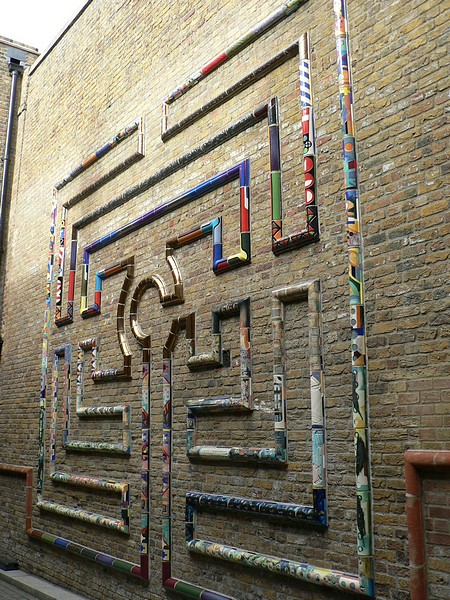
Image: © Rich Tea Taken: 20 Oct 2007
This wall maze is in an alley leading to a small group of shops off Caledonian Road, about 50 yards north of the Pentonville Road junction. Its made of multicoloured tiles projecting from the wall, many of which are worth detailed inspection - for instance one appears to be a copy of a computer keyboard in reverse. A tile at the bottom names the artist as "Philip O’Reilly London 2005" - perhaps the same Philip O’Reilly who is senior lecturer at the Cardiff School of Art and Design. The maze is a "City of Troy" type, an ancient unicursal design with a single path, which were of religious significance. (As for example the modern turf maze at St Albans Abbey) Some years after taking this photo, I received an e-mail from the artist himself in February 2013 :- It is entitled "The Kings Cross Labyrinth" and created as part of the development of the 'B' Block site where it is situated. Commissioned by P&O Properties, it took 2 years in the making. I have a substantial document of its development stage by stage. It has a narrative based on the local area of Kings Cross, plus other stuff I put in for my own interests or experiences. It was made in my studio in Peckham, London, unfortunately now closed due to prohibitive costs. I also made the mural on the opposite side of the site. "Text-Wall" is in cast Aluminium LM25 recycled metal, in 47 panels, entirely designed on my 12" laptop, CNC routed and cast in Dartford, Kent at Maybrey Foundry. A fantastic experience working there and managing the whole project. The texts all refer to info given by English Heritage in their guidebook to the site and its listed buildings etc. Thanks for the picture. Geograph seems to be a good idea. The original maze by the way, is 8th C and situated near Northampton. I changed its format somewhat but is in essence the same plan. Visit http://philiporeilly.co.uk/ to see Philip O'Reilly's website.
Images are licensed for reuse under creativecommons.org/licenses/by-sa/2.0
Image Location
Latitude
51.531216
Longitude
-0.121326