Information Board at Watlington Car Park
Introduction
The photograph on this page of Information Board at Watlington Car Park by David Hillas as part of the Geograph project.
The Geograph project started in 2005 with the aim of publishing, organising and preserving representative images for every square kilometre of Great Britain, Ireland and the Isle of Man.

There are currently over 7.5m images from over 14,400 individuals and you can help contribute to the project by visiting https://www.geograph.org.uk
Information Board at Watlington Car Park
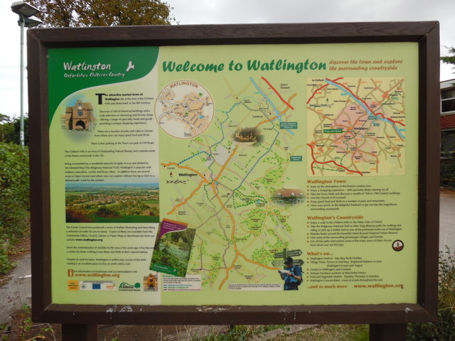
Image: © David Hillas Taken: 27 Aug 2018
Situated in Hill Road, OX49 5AB, this information board is located by the car park. It has the following wording: Left hand side Watlington Oxfordshire Chilterns Country The attractive market town of Watlington sits at the foot of the Chiltern Hills, and dates back to the 8th Century. The town is full of historical buildings and a wide selection of interesting and diverse shops offering a range of speciality foods and goods providing a unique shopping experience. There are a number of pubs and cafes to choose from where you can enjoy good food and drink. There is free car parking in the Town car park in Hill Road. The Chiltern Hills is an Area of Outstanding Natural Beauty and contains some of the finest countryside in the UK. Being surrounded by a wonderful network of rights of way and skirted by the Icknield Way (The Ridgeway National Trail), Watlington is popular with walkers, naturalists, cyclists and horse riders. In addition there are several areas of Open Access land where you can explore without having to stick to a defined path. Look for the symbol (it is the brown and white symbol on the extreme right of the board). The Parish Council has produced a series of leaflets illustrating and describing a selection of walks for you to enjoy. Copies of these are available from the Community Office, Church, Library or Paper Shop or download one from our website "www.watlington.org". Since the reintroduction of red kites to the area a few years ago, it has become a centre from those wishing to see these rare birds in their natural habitat. Despite its royal location, Watlington is within easy access of the M40 making it an excellent place to live, work and to visit. Middle Welcome to Watlington A large map of Watlington and the surrounding area, plus a street map of Watlington at the top left hand corner. Right hand side discover the town and explore the surrounding countryside Smaller Map of Watlington and the surrounding area. Watlington Town i) Soak up the atmosphere of this historic market town ii) Enjoy a shopping experience - with specialist shops catering for all iii) Take the Town Walk and discover a wealth of 15th to 19th Century buildings iv) Visit the Church of St Leonard v) Enjoy good food and drink in a number of pubs and restaurants vi) Have your picnic in the delightful Paddock or get out into the magnificent surrounding countryside Watlington's Countryside i) Enjoy a walk in the Chiltern Hills or the flatter Vale of Oxford ii) Take the Ridgeway National Trail or other long distance paths for walking and riding or pick up a leaflet and try one of the promoted walks out of Watlington iii) Wander freely around the beautiful Aston Rowant National Nature Reserve iv) Visit some of the surrounding picturesque villages and hamlets v) Get off the paths and explore some of the many areas of Open Access land where you see this sign (to the right of this wording) What's On i) Watlington Festival - late May Bank Holiday ii)Village Fetes: Pyrton in mid May, Brightwell Baldwin in June, Watlington in June and August iii) Cricket in Watlington and Cuxham iv) Antique Furniture auctions at Watcombe Manor v) Fruit and Vegetable Market - Tuesday, Thursday & Thursday vi) Watlington Concert Band - musical events throughout the year and so much more "www.watlington.org"
Images are licensed for reuse under creativecommons.org/licenses/by-sa/2.0
Image Location
Latitude
51.644257
Longitude
-1.003198