Speybridge House
Introduction
The photograph on this page of Speybridge House by Anne Burgess as part of the Geograph project.
The Geograph project started in 2005 with the aim of publishing, organising and preserving representative images for every square kilometre of Great Britain, Ireland and the Isle of Man.

There are currently over 7.5m images from over 14,400 individuals and you can help contribute to the project by visiting https://www.geograph.org.uk
Speybridge House
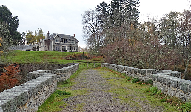
Image: © Anne Burgess Taken: 5 Nov 2018
The house at the end of the Old Spey Bridge is not on the first edition of the Ordnance Survey six-inch map, but it is marked and named as Viewhill on the second edition, so it must have been built in the late 19th century. The current online maps show it as a hotel, but the sign at the gate says Speybridge House, and there is no mention of a hotel. The bridge dates from 1754, though the northernmost of its three arches had to be rebuilt after damage in the great floods on 1829. The Speyside Way crosses the River Spey on this bridge, which is now closed to motor vehicles.
Images are licensed for reuse under creativecommons.org/licenses/by-sa/2.0
Image Location
Latitude
57.316758
Longitude
-3.596049