In search of the M&SWJ: water-tower at Faberstown
Introduction
The photograph on this page of In search of the M&SWJ: water-tower at Faberstown by Stefan Czapski as part of the Geograph project.
The Geograph project started in 2005 with the aim of publishing, organising and preserving representative images for every square kilometre of Great Britain, Ireland and the Isle of Man.

There are currently over 7.5m images from over 14,400 individuals and you can help contribute to the project by visiting https://www.geograph.org.uk
In search of the M&SWJ: water-tower at Faberstown
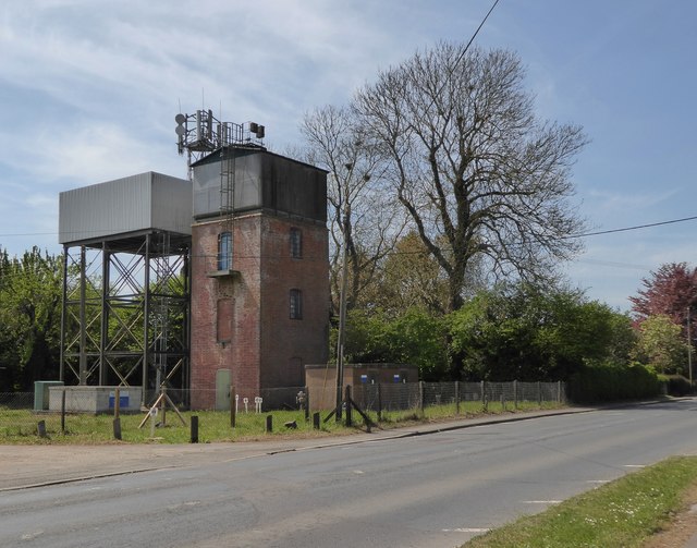
Image: © Stefan Czapski Taken: 10 May 2017
These two towers stand close to the route of the old Midland & South-Western Junction Railway, east of Ludgershall. The one with the open steel frame is a recent structure, but the brick-built one is plainly a relic of the steam age. It stands at a certain distance from the surviving railway line - but I'd read that as evidence that the land between line and road was once a railway yard. The M&SWJR existed as an independent entity from 1884 until 1923, when it was absorbed into the Great Western. Its main line (if 'main line' you could call it) ran cross-country from Swindon south to Andover and north-west to reach Cheltenham. Traffic seems to have been pretty sparse except during the two world wars. At the time of writing, the line still connects a military depot at Ludgershall with the national rail network at Andover.
Images are licensed for reuse under creativecommons.org/licenses/by-sa/2.0
Image Location
Latitude
51.251461
Longitude
-1.601621