
Carrow Works block 7
Introduction
The photograph on this page of Carrow Works block 7 by Evelyn Simak as part of the Geograph project.
The Geograph project started in 2005 with the aim of publishing, organising and preserving representative images for every square kilometre of Great Britain, Ireland and the Isle of Man.

There are currently over 7.5m images from over 14,400 individuals and you can help contribute to the project by visiting https://www.geograph.org.uk
Carrow Works block 7
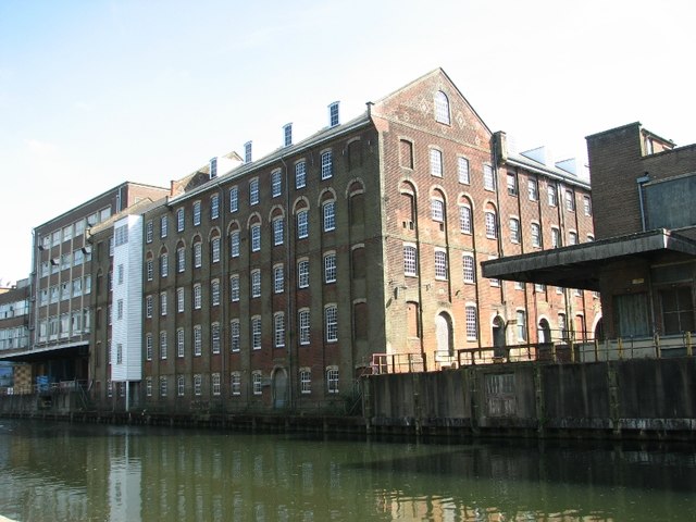
Image: © Evelyn Simak Taken: 18 May 2018
This Grade 2 listed composite group of factory buildings comprising blocks 7, 7A, 8A and 8 dates from the last quarter of the 19th century and was built from Somerleyton bricks to an F-shaped plan, with slate roofs. The ragstore block (block 7) and the smithy and engineers shop (8 and 8A) date from 1856 but block 7 was rebuilt in 1881 > http://www.geograph.org.uk/photo/5782777 following a fire. In 1880, the tinmans shop was built on the site of the original papermill, smithy and fibre house. A round-arched carriageway giving access to block 7 and an adjacent metal canopy, segmental in section > http://www.geograph.org.uk/photo/5782775 are particularly noteworthy. This part of the Carrow Works has (as yet) not been re-developed. The Carrow Works were owned by the Colman family of mustard fame. Jeremiah Colman had started his mustard and flour business in 1814 at Stoke Holy Cross. It was, however, his great-nephew Jeremiah James Colman who in 1850 bought land from Norfolk Railway at Carrow, and in 1858 brought the company to Carrow and established the Carrow Works which by 1869 had 1100 employees. Colman’s won a special place in the heart of workers in the city, because the company looked after its employees, who enjoyed better conditions than in many other city factories. Many of the old Carrow Works' industrial buildings have since been converted into housing.
Images are licensed for reuse under creativecommons.org/licenses/by-sa/2.0
Image Location

Latitude
52.620053
Longitude
1.309831