Scotch Street (east side) ? The Lanes - February 2018 (1)
Introduction
The photograph on this page of Scotch Street (east side) ? The Lanes - February 2018 (1) by The Carlisle Kid as part of the Geograph project.
The Geograph project started in 2005 with the aim of publishing, organising and preserving representative images for every square kilometre of Great Britain, Ireland and the Isle of Man.

There are currently over 7.5m images from over 14,400 individuals and you can help contribute to the project by visiting https://www.geograph.org.uk
Scotch Street (east side) ? The Lanes - February 2018 (1)
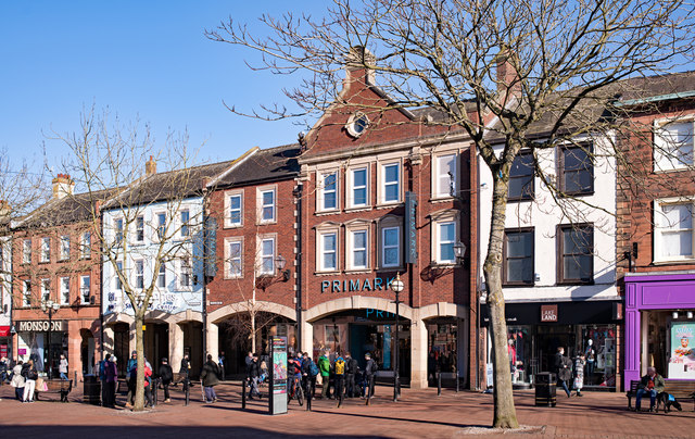
Image: © The Carlisle Kid Taken: 25 Feb 2018
Situated behind the east side of Scotch Street, a warren of alleyways known as “The Lanes” may have dated back to the 11th Century. The area contained a considerable number of pubs and, while some vanished before 1916, the State Management Scheme acquired at least seven, of which four were almost instantly closed with a fifth following in 1927. By the 1950s, the area was falling into dereliction and various schemes were proposed for redevelopment. However, the Council dithered - and had no money - so there was little actual movement until the late 1970s, by which time many of the buildings were in danger of structural collapse. Work on what is now “The Lanes” Shopping Centre began in 1980, with period photographs showing the site was completely cleared from Scotch Street to Lowther Street, with almost no original buildings surviving. The Centre opened in 1984 and, while the current east front to Scotch Street is a reconstruction, it follows as close as possible the pre-1980 appearance. This first view is at the junction of Scotch Street and English Street. Behind this façade were four pubs - the Dog & Bull Inn (to the right of Primark), the Gleaner Inn and the Grapes Hotel (behind Primark and to the left) and the Crown & Anchor Inn. Only the "Crown & Anchor" survived to the State Management era, being acquired on 3 August 1916 and closed in 1916. See also: Image], Image], Image] and Image Photograph is for record only – I have no connection with any business seen in this view and cannot advise on their products or services.
Images are licensed for reuse under creativecommons.org/licenses/by-sa/2.0
Image Location


Leaflet Map data © OpenStreetMap
Latitude
54.894678
Longitude
-2.935312