High Street, Clacton-on-Sea
Introduction
The photograph on this page of High Street, Clacton-on-Sea by Duncan Graham as part of the Geograph project.
The Geograph project started in 2005 with the aim of publishing, organising and preserving representative images for every square kilometre of Great Britain, Ireland and the Isle of Man.

There are currently over 7.5m images from over 14,400 individuals and you can help contribute to the project by visiting https://www.geograph.org.uk
High Street, Clacton-on-Sea
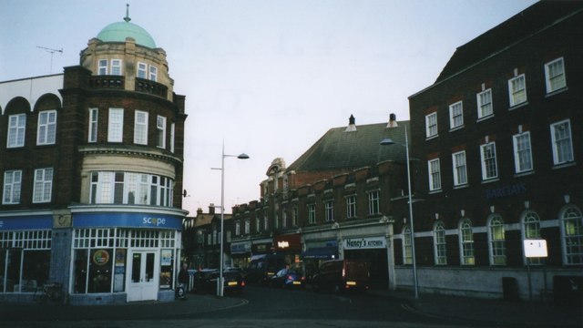
Image: © Duncan Graham Taken: 8 Feb 2008
This shows the High Street (2008), looking north-east. It was photographed from the traffic island at the junction of Station Road, Rosemary Road and the High Street. The Scope charity shop on the left is now (2018) a Sense charity shop; in the 1950s it formed part of Barclays Bank with the Barclays building opposite visible in the picture. Earlier still (pre-1931), it housed Clacton Town Hall as well as the bank. The right-hand branch of Barclays is now a Coral bookmaker. [Sources: "Clacton-on-Sea: a Pictorial History" by Norman Jacobs, 1993; personal observation].
Images are licensed for reuse under creativecommons.org/licenses/by-sa/2.0
Image Location
Latitude
51.789782
Longitude
1.153797