Panorama from Tantallon, Donaldfield Road 1960's
Introduction
The photograph on this page of Panorama from Tantallon, Donaldfield Road 1960's by David A Paterson as part of the Geograph project.
The Geograph project started in 2005 with the aim of publishing, organising and preserving representative images for every square kilometre of Great Britain, Ireland and the Isle of Man.

There are currently over 7.5m images from over 14,400 individuals and you can help contribute to the project by visiting https://www.geograph.org.uk
Panorama from Tantallon, Donaldfield Road 1960's
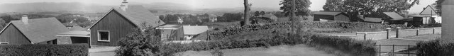
Image: © David A Paterson Taken: Unknown
Taken by my father at my childhood home, this picture taken in the mid 1960's shows some detached houses, at least one of which appears to have been demolished and rebuilt more recently (per Google Street View), and to the right some of the farm buildings that stood at the top of what is now St Andrews Drive. The side of the lorry reads "John Robertson" with a Bridge of Weir phone number. From here you can see the City of Glasgow. I distinctly remember looking at the QE2 during its construction. I was therefore proud that my eldest son was serving on HMS Lancaster when his ship accompanied the QE2 to its final resting place in Dubai in 2008. Can't be many of this view around hence my posting it!
Images are licensed for reuse under creativecommons.org/licenses/by-sa/2.0
Image Location
Latitude
55.8512
Longitude
-4.592577