
Dromore Abbey
Introduction
The photograph on this page of Dromore Abbey by Kenneth Allen as part of the Geograph project.
The Geograph project started in 2005 with the aim of publishing, organising and preserving representative images for every square kilometre of Great Britain, Ireland and the Isle of Man.

There are currently over 7.5m images from over 14,400 individuals and you can help contribute to the project by visiting https://www.geograph.org.uk
Dromore Abbey
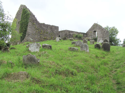
Image: © Kenneth Allen Taken: 20 Sep 2005
The site of this ruined church, located on a rocky promontory, has been modified over recent centuries but it is clear that the foundation date for the present church is post-plantation as it is shown on the Down survey map ca. 1655-60. A number of archaeological features were discovered lying on or just below the surface when it was excavated. The most obvious was a large grave slab. Also uncovered were six skeletons, three each in the nave and transept. The slab uncovered dates to the 1670s and may relate to the Mervyn family who lived in Trillick Castle a short distance from Dromore. It was probably built in the early 17th century. It consists of a rectangular nave 20m x 7.5m with a 7mz transept projecting from the middle of the south wall. A number of architectural details survive including several windows. The building is surrounded by a disused graveyard. At the base of the promontory below the church is a spring, known locally as the "Eye Well", which is believed to have curative powers.
Images are licensed for reuse under creativecommons.org/licenses/by-sa/2.0
Image Location

Latitude
54.511515
Longitude
-7.463317